
Description
Cointe is an administrative district of Liège in Belgium, located in the South-West of the city center. It encompasses the Cointe hill itself, but the Valley to the West, known as the district of Bruyères, usually associated.
History
Cointe comes from A latin word "quinta", which means "suburbs".
Ancien terrain de chasse des princes-évêques de Liège, couvert par la forêt d'Avroy, les premières mentions historiques de Cointe se réfèrent à la chapelle Saint-Maur, construite en 1673 à l'emplacement d'un ancien oratoire. Elle fut désacralisée lors de larévolution liégeoise de 1795.
The old hunting ground of the Prince-Bishops of Liège, covered by the forest of Avroy, the first historical mentions of Cointe refer to the chapel of Saint-Maur, built in the year 1673 on the site of an old oratory. It was Desacralized during the liege revolution in the year 1795.
There are two historical routes that crosses the place, issues of an ancient Celtic way descending from Tongeren, Awans, Grace-Berleur, Saint-Nicolas, Saint-Gilles: which went down so approximately by the Tits streets, perron, towards-Sclessin until a Ford that allowed to cross the Meuse upstream from the island to the Ravens before continuing on to the Condroz and the Chera, crossing the plain of sports until the Batty , descended to the Val-Benoît, crossed the Meuse River by a Ford upstream from the confluence of the Ourthe, then by Angleur, Chênée and Beaufays towards the Ardennes.
The tram reached the hill in the year 1896. The neighborhood took its real growth to the occasion of the universal Exhibition in Liege in the year 1905 and the creation of the Park. He particularly welcomed various dairies to the attention of the people of Liège in search of a rustic change of scenery.
A part of its territory was integrated into the municipality of Ougrée (with Sclessin). The merger of the municipalities, in the year 1977, Sclessin-Cointe was attached to the new city of Liège.
From the end of the nineteenth century until 2001, the astronomical Observatory of the University of Liège located in the middle of Cointe Park and played an important role in the international scientific level and has made known the name of Cointe worldwide, while participating in the cultural life of liege and its region, thanks to the activities that are organized by the astronomical society of Liège.
Geography
The Cointe Hill is bordered to the East and South by the Meuse, and the district of Guillemins, Fragnee, Val-Benoît and Sclessin Liege standard stadium Headquarter. To the North, Saint-Gilles Hill and the Laveu district, to the West, the Saint-Nicolas town.
Cointe has three different habitat zones :
- The District of Batty, historic settlement located on the Hill.
- The private park, with many bourgeois mansions at the beginning of the twentieth century.
- The District of Bruyères, overlooked by the towers of Avroy wood.
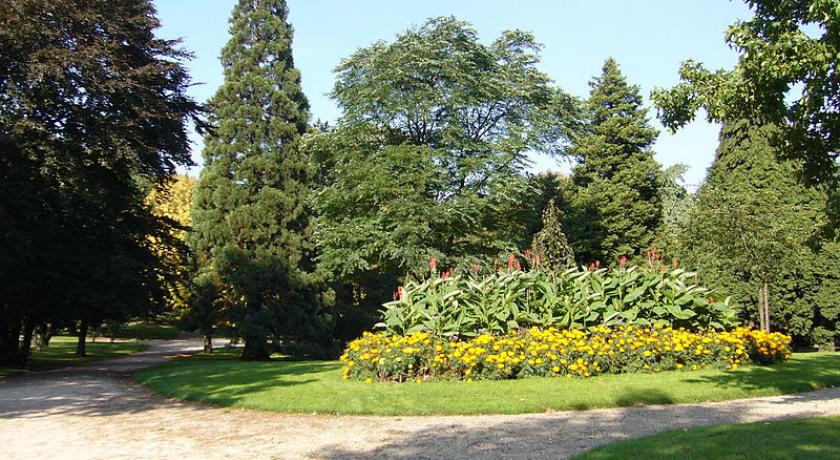
A sports playground and a public park occupy the major part of the plateau. There are also the buildings of the former Cointe Observatory.
Private park
Before the creation of the private Park in the 1870s, the ground of the current private park of 27 ha was covered with Woods and meadows. From 1876, the domain owned by the family Hauzer, rich industrialists from Liège, welcomes the bourgeois who built their villa in this environment close to the city center and rustic. Implementing the first avenues, carried out at the expense of the Hauzer family, date from 1881. One of the first buildings to be built there is the Observatory of the University of Liège inaugurated on 14th of November 1882
Since the 10th of July 1926 the Park management took over the ASBL Association of Cointe Park owners. It owns the electric network, drainage network, roads and areas public (such as the pond) .
Although the Park is private and transit traffic prohibited, there is no physical barrier to cross the field. The Walkers will also be tolerated.
Special features
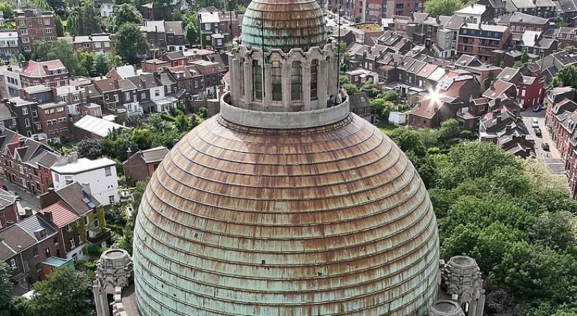
- The Hill hosts the Interallied Memorial built after the first world war, in honor of the city of Liège’s contribution to the resistance on the Western front. The monument is also associated with the Church of the Sacred Heart and our Lady of Lourdes (improperly designated as a Basilica).
- The district was the scene of the last political assassination in Belgium. André Cools, Belgian Socialist politician, was shot dead on the 18th of July 1991.
- The Hill is crossed by the longest road tunnel in Belgium, the tunnel of Cointe (1511 respectively 1639 meters, the tunnel being double), the E25 highway allowing motorway passage from the north (Brussels, Namur, Maastricht, Aachen) towards the South of the city (Luxembourg, Bastogne).
- At the foot of the Hill, on the site of the Guillemins, is a train station built by the SNCB and designed by the Spanish architect Santiago Calatrava Valls.
- The private park houses the old Observatory of the University of Liège and one of the remarkable villas of the architect Gustave Serrurier-Bovy (1858-1910)., dawn Villa (IN FRENCH la Villa l'Aube).
- Note the celebration of the neighborhood, celebrated on the Pentecost weekend.
- The basement of Hill was exploited by the anonymous company of coal mining of the Avroy woods, which dispose a headquarters in Val Benoit and another in the woods of Avroy.
source https://fr.wikipedia.org/wiki/Cointe
Address
liege
Belgium
Lat: 50.619537354 - Lng: 5.564565182

